Climates
Transport Fever 3 has the ability to define different climate zones. They vary in the look and feel of the environment, as they have different plants, colors, terrain textures and lighting.
Configuration
A climate zone is defined in a .clima.lua file. The file has the following setup:
function data()

return {
  id = "temperate",
  desc = {
    name = _("Temperate"),
    description = _("Mixed Forest Vegetation"),
    icon = "temperate.tga"
  },
  order = 1,
  category = "temperate.clima",

  defaultNames = "/names/europe/europe.names",
  economy = "/economy/temperate.eco",
  environment = "temperate.env",

  nodeTree = "temperate_clima.tree",

  audio = { environment = {...}},
  mapColoring = {...},
  groundTextures = {...},
  skirt = {...},
}
end
While id is a unique technical identifier, name and description are strings which can be translated in a strings.json file. The referenced ui icon for climates is used in some main menu dialogs and is 600x400 px in @2 resolution. The climate zones are ordered in the dialogs according to their order values and the category key is used to filter trees and other game resources properly.
To set the default game settings per climate zone, the following properties reference the equivalent game resources:
defaultNamesreferences the default name set to be used for towns, bus stop and people names.economyreferences the default economy to be played in this climate zone.environmentreferences the sky and water environment settings to be used in this climate zone.
The nodeTree reference points to the node tree used for material distribution.
Environmental sounds can be configured in audio.environment.
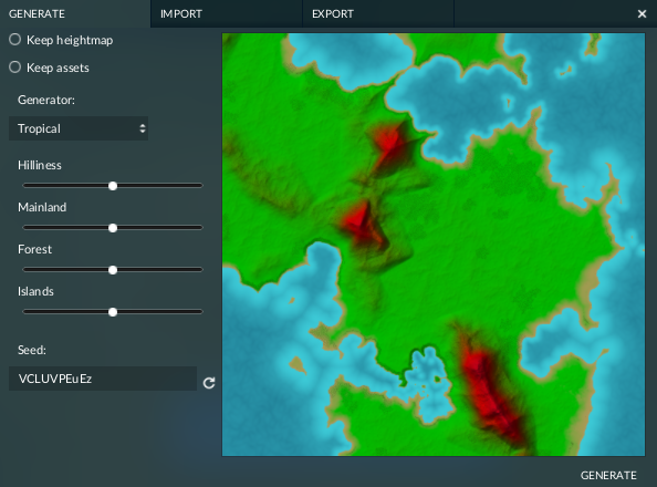
The mapColoring struct defines the colors that are used for the map preview in terrain generator dialogs. It has several properties:
levelsis a list of level definitions. Each level stands for a color at a certain height and consists of two values:coloris a color definition with three values between 0 and 1 for the red, green and blue channel.heightis the height level at which this color should be used. Intermediate height levels are interpolated between colors.
waterColor0is the color definition for the shallow water in the shore area.waterColor1is the color definition for the deep water area.ambientColoris the color definition for the overall color grading of the preview map.sunColoris the color definition for the sun exposure.

The groundTextures struct is used to assign special .gtex ground textures for several purposes:
waterGroundis the texture that is used below water, e.g. in lakes and rivers.waterShoreis the border texture that is used along the shoreline.
The skirt struct is used to define the textures used for the edges of the game world:
1 colorTex is the texture map that is used as base colors for the edge faces.
2 detailTex is the texture map that is used as overlay to get some randomzation of colors at the faces.
3 waterText is the texture map that is used as base color for the areas of edge faces that touch water.
Environment Audio
The environmental sounds are configured in the audio.environment struct of the climate. There are different types of configurations, all basing on a few standard properties:
mountain = {
  sounds = {
    { file = "::/climates/sound/environment/nature/mountain.wav" }
  },
  refDist = 15.0,
  height = 0.0,
  layer = 3,
  ambient = true,
  altitudeRange = { 200.0, 4000.0 },
},
The properties are:
soundswith a list of sounds, see details below.refDistis a numeric value describing the reference distance for the standard loudness of the sound.heightis a numeric value to define the height above ground where the sound is emittedlayeris an integer used to prioritize sounds. The environment audio system will prefer to play sounds from the layer with the lowest number, if any sound from a layer is used, then sounds of higher layer won't be played. If a layer has multiple sounds defined, a mix of them will play.altitudeRangeis pair of boundaries to restrict the sound to a certain camera height.ambientis a flag to mark this sound to be a fallback if no other environment sound is active.
The following keys can be used for the structs:
water: Sounds used where there's a water mesh.forest: Sounds used where tree density is high enough.traffic: Sounds used where cars are present.crowd: Sounds used where person are present.atmosphere: Wind sounds for the sky. This audio source is always active and fixed at 4000m altitude.rain: The audio source is always at the camera position and the volume depends on the rain intensity.lowland/mountain: they use theambientflag. If no other sounds are playing, those will try to play based on their conditions.
Additionally there are keys for every district in towns: residential, commercial and industrial. They each have a list of 4 entries describing the 4 building levels.
To add custom sound layers, the key terrainMasks holds a list with struct entries. The keys of the structs need to match the mask keys exported with Data Output nodes during map generation.
The sounds list contains substructs with two keys:
- file: the file path to the sound resource
- tags: a list of tags used to filter the sounds, see below.
Only one matching sound out of the sounds list is played at a time.
The following tags are available:
"day": set during the daytime, for now fixed based on game time, the day always starts at 6:00 and ends at 19:00"night": set during nighttime"clear": set when the sky is clear (opposite of rain)"rain:": set when it's raining (opposite of clear)"year1900": set between 1900 and 1919"year1920": set between 1920 and 1989"year1990": set from 1990 onwards
Terrain Material Distribution
The nodeTree of climates is called after every change of terrain to recalculate the default terrain texture distribution over the map. It can be edited with the Terrain Generator Editor included in the Map Editor.
Inputs
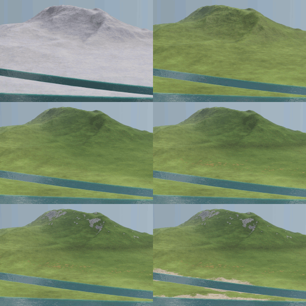
layers generated by updateFn
The tree may get multiple inputs:
Heightmap inputis used to retrieve the actual heightmap of the map.Map datais used to retrieve the map size and seed value:Seedcontains the map seed as number output.Map bounds min.provides the x an y minimums of the map bounds.Map bounds max.provides the x an y maximums of the map bounds.Water levelis currently not provided .
.
Data inputis used to retrieve masks saved during map generation. It receives aKeyparameter to identify the right mask.
All three types of nodes can be used multiple times.
Output
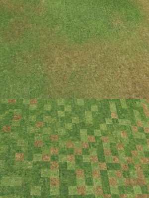
no dithering and dithering
The tree may generate one or more terrain material masks. Each mask output is defined in a Material Output node that receives a Material Map as the map that will be used to draw the material (transparency value between 0 and 1). Additionally it receives several parameters:
Orderis the integer number used as layer order of this terrain material.KeyisMaterial typeis the reference to the terrain material that shall use this mask.Ditheris a boolean parameter used to select if the material should be dithered / mixed with the neighbors.
To define the underlying base terrain material, a Material background output node needs to be added as well. It just has one parameter Material type to reference the terrain material.